In an estuary, freshwater inflows mix with seawater. Mixing is affected by the amount of seawater in the estuarine system. The tides and the volume of the receiving estuary govern the volume of seawater. The periodic rise and fall of the surface of the sea along the coast that are driven by the gravitational pull of the moon and of the sun are called tides (Sumich 1996). The Earth has large continents and is shaped spherically but without continents, there would be two high and low tides each lunar day (Sumich 1996). The continents interfere with the westward movement of the tidal bulges causing intricate tidal patterns within each ocean basin that different from one another (Sumich 1996).
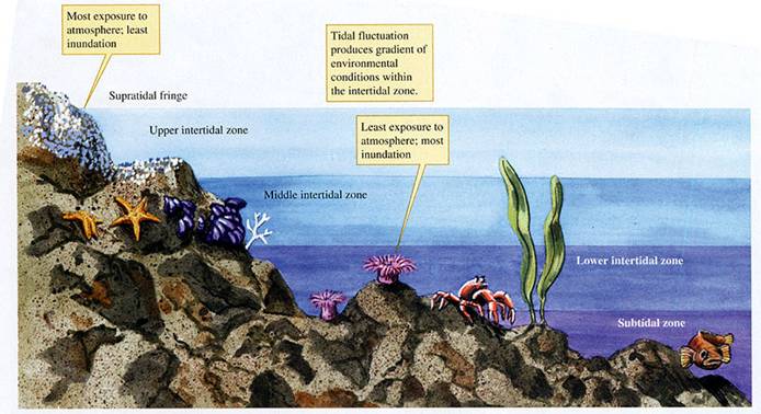
Tidal changes are important to the coastal plants and animals that live on the boundary between land and sea in the “intertidal zone.” Tides occur in different cycles depending on the region and the time of the year. Diurnal tides occur when there is one high and one low tide a day. Semidiurnal tides occur when the rise and fall of the tides takes place twice each day. Semidiurnal mixed tides are where there are unequal tidal heights each day. Tidal levels also vary depending on what region they occur. Some tidal ranges can be small and some can be large. Tidal ranges fall into one of three categories: if the tidal range is less than 1 meter, it is microtidal; if the tidal range is above 1 meter and below 3 meters, it is mesotidal; if the tidal range is greater than 3 meters, it is macrotidal (Montagna et al. 2013).
Different freshwater inflows and tides create variations of circulation patterns in estuaries. Estuaries may be categorized as salt-wedge, well-mixed and partially mixed estuaries depending on the driving force that mixes the estuary. When river flow drives mixing in estuaries, the freshwater flows over seawater causing stratification and is categorized as a salt-wedge estuary. Wind drives the mixing in a well-mixed estuary and there is a salinity gradient that increases from the river to the estuary. Tides drive the mixing in a partially mixed estuary causing some stratification of bottom saltwater and top freshwater with gradient variation at different areas of the estuary. For example, the Gulf has one high and one low tide, or diurnal, the U.S. West coast typically has mixed semidiurnal tides, the U.S. East coast has a more semidiurnal pattern (Montagna et al. 2013).
Flow dynamics can be understood by determining the rate at which water enters and leaves an estuary or the flushing time. The flushing time equals the volume of the estuary divided by the flow of water leaving the estuary. The flushing rate is the controlling factor of almost all estuarine processes. The flushing time can provide information on how estuaries function including the flushing time for nutrients, wastes, sediment, and organic matter, the effects of mixing, and information on many other processes (Montagna et al. 2013). Tidal mixing near shore allows for the removal of pollutants from estuaries and the circulation of nutrients. Tidal movement also transports floating organisms and vegetation to and from breeding areas to deeper water offshore.
The National Oceanic and Atmospheric Administration (NOAA) is an ocean service agency that has been measuring, describing, and predicting tides along the coast of the U.S. since the early 1800s (NOAA 2013). A branch of NOAA that continues to record and publicize water level data is the Center for Operational Oceanographic Products and Services, CO-OPS (NOAA 2013). The current system used by the agency uses technology that is more accurate, has advanced acoustics and electronics, records many parameters, and transmits recorded data hourly via satellites (NOAA 2013). A recorder sends an audio transmission down a half-inch-wide sounding tube and measures the time it takes for the echo to reach the surface of the water to accurately measure tidal heights (NOAA 2013). Some of the parameters measured include wind speed and direction, water current speed and direction, and air and water temperature. Raw data recorded by NOAA’s agency branches is available over the Internet (NOAA 2013).
Raw data recorded by NOAA’s agency branches is available online.